
Source: SDG&E
January 25, 2025 (SDG&E) – San Diego Gas & Electric (SDG&E) announced this evening that power has been fully restored to all customers affected by recent Public Safety Power Shutoffs (PSPS). Over 19,000 customers were impacted in dozens of local communities. These shutoffs were implemented as a wildfire prevention measure in response to unprecedented weather conditions that led to prolonged high-fire risk.
 Update 8:46 p.m.-- The fire is now 600 acres, per Watch Duty App. No structures are currently threatened.
By Miriam Raftery
Photo, left, by Jeff Caton, taken from the intersection of Fletcher Parkway and Cuyamaca St. in El Cajon this evening.
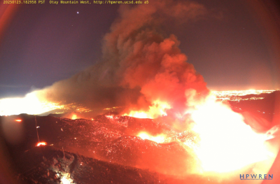
Photo, right: Border 2 Fire viewed from HP Wren Otay Mountain West camera
January 23, 2025 (San Diego’s East County) – The Border 2 Fire burning on Otay Mountain has swelled to 566 acres as of 7 p.m. tonight. The flames are visible as far north as Escondido and Ramona. There is zero containment as yet.
The fire which began early this afternoon was burning at a “dangerous” rate of spread, Watch Duty App reported, however this evening Cal Fire indicates it is growing at a moderate rate as winds have lessened.
No evacuation notices have been sent out by the County, though campers at Pio Pico and Thousand Trials have posted on social media that they were advised to evacuate or prepare to evacuate.
Update 5:05 p.m.-- The #Border2Fire is now 248 acres and still 0% contained. Winds have shifted toward campgrounds with campers at Pio Pico told to evacuate and Thousand Trails campers receiving a warning to be prepared, per social media posts from campers at these sites.
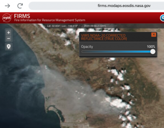 update 4 p.m.-- The fire is now 148 acres per Watch Duty app and is large enough to be visible from space. (Photo, right, via NASA)
Update 3:45 p.m.-- The fire is now 50 acres and 0% contained, per Cal Fire.
By Miriam Raftery
Photo by Barry Jantz: Border 2 Fire viewed from Jamul, with Jamul Casino in foreground.
January 23, 2025 (San Diego's East County) -- The #Border2Fire that started within the hour on Otay Mountain is now 20 acres and burning at a "dangerous" rate of spread, per Watch Duty App. Cal Fire lists the size as 10 acres with potential for 200 acres.
The fire started near Otay Truck Trail in the Otay WIlderness area. Infrastructure on the mountain is threatened, per Watch Duty App.
East County News Service
January 22, 2025 (Lemon Grove) — In the wake of the devastating fires that have swept through Los Angeles, Lemon Grove non-profit service clubs such as the Lemon Grove Lions, Lemon Grove Forward Club, Thrive, Soroptimists International of Lemon Grove, Mt. Miguel High School Alumni and the Lemon Grove Fire Department to name a few, are uniting to provide much-needed assistance to affected families and communities. These dedicated organizations are hosting a fundraising event on Sat, Feb 1st at Treganza Park from 12:00 p.m. to 3:00 p.m.
Update 4 p.m.: Evacuations have been listed and forward spread has been stopped.
Update 11 a.m. -- The evacuation center at Castle Creek Golf Course has closed. Evacutees should go to Riverview Church,4980 Sweetgrass Lane in Bonsall.
January 21, 2025 (Bonsall) -- The #LilacFire in Bonsall has burned 80 acres and destroyed two homes, with 10% containment. Mandatory evacuations have been ordered. The fire is burning along Old Highway 395 and North Lilac Rd.
View evacuation areas at the Genaysis mapping site. An evacuation center is at the Castle Creek Golf Course, 8797 Circle R Drive in Escondido 92026. Large animals can be taken to the CRC Ranch at 43101 Anza Rd in Temecula - per San Diego Sheriff's on X.
All schools in Bonsall are closed today due to the fire, according to the Bonsall Unified School District.
A second blaze that started overnight, the Pala Fire, is 100% contained at 17 acres. That fire was located west of I-15 and 2 miles north of Highway 76 in Pala.