Image


East County News Service
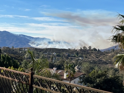
January 28, 2025 (Jamul) -- Robert Hobbs sent in these images of the Border 2 Fire, which burned over 6,500 acres after starting on Otay Mountain in San Diego County on Jan. 23. These photos were taken Jan. 23 and 24 from Jamul.
By Miriam Raftery
Photo courtesy of Cal Fire
Update January 30,2025 10 a.m.-- All evacuation orders have been lifted. The fire is 100% contained.
Update January 29, 2025 9 a.m.-- The Border 2 Fire is now 90% contained, as rain helped firefighters' efforts. Cal Fire says there is no risk to the public or structure threats.
Update January 27, 2025 12 p.m.-- The overnight shelter at Cuyamaca College has closed. All evacuation warnings remai lifted. Some evacuation orders remain in effect in areas west of highway 94. For map, see: https://x.com/SDSheriff/status/1883974136143438278/photo/1.
Update 7:45 p.m. -- The fire is now 40% contained, per Cal Fire.
Update 5 p.m.-- All evacuation warnings have been lifted. Some evacuation orders remain in areas west of 94. Use caution when reentering, as firefighters are still at work.
Update 1 p.m.-- State Route 94 is reopened; evacuation notices for Dulzura, Honey Springs, and areas east of 94 have been lifted; these areas will be repopulated. Otay Lakes Rd. remains closed. To see maps of the affected areas, visit: emergencymap.sandiegocounty.gov/index.html and protect.genasys.com/fullscreenMap?.
January 26, 2025 8:30 a.m.— Firefighters held the #Border2Fire to 6,625 acres overnight and 10% contained. State Route 94 remains closed between Honey Springs Road and State Route 188.Tecate Rd. Evacuations remain in effect; view current evacuation areas: Genasys Evacuation Map. 1,117 personnel are fighting this fire.
Experts are looking at the soil in the fire’s perimeter to evaluate if there are any mudslide concerns and will work to mitigate those if they arise.
Cal Fire held a virtual community forum last night which can be viewed here. Cal Fire reports good progress on the fire, especially on the west side near Chula Vista Due to improved conditions, the Sheriff reports that jail visits will resume at the 3 Otay facilities.
On the east side and near Doghouse Junction, crews are constructing a containment line to prevent the fire from moving east towards Dulzura, Marron Valley, and Mexico.
.On the south side of the fire, there is some open line on the fire, but resources are working in arduous terrain to combat it. On the southwest side, ground crews and dozers continue to build line to prevent the fire’s spread.
East County News Service
January 25, 2025 (Rancho San Diego, CA) -- In light of the ongoing evacuations at the Border Fire, the Water Conservation Garden on the campus of Cuyamaca College is opening its grounds with free admission to evacuees and their pets. Free Wifi is available.
“We hope The Garden can provide a peaceful escape, a place to recharge, and a reminder of the resilience of nature and community,” says Lauren Magnuson, Director of Garden Operations. She adds, ”Stay safe, and we look forward to welcoming you.”
Update January 25, 2025- The fire had modest growth overnight and is now 6,500 acres, per Cal Fire.
Update 8:15 p.m.-- Per CalTrans, State Route 94 is closed in both directions between Honey Springs Rd. in Jamul and State Route 188 (access road to Tecate) due to the fire.
Update 5:55 p.m.-- The fire is now 6,272.7 acres per Cal-Fire. The mandatory evacuation area has been extended to some areas east of State Route 94.
January 24, 2025 (Jamul/Dulzura) -- Evacuation orders and warnings for the #Border2Fire now extend to immediately south of Jamul Casino, including areas east and west of State Route 94, and significant portions of Chula Vista. Photo left is as of 1 p.m.; click this link for latest evacuation areas and hit the plus sign to enlarge to view details: https://app.watchduty.org/camera/2231 Also see another map here: https://www.fire.ca.gov/incidents/2025/1/23/border-2-fire.
The fire, which started on Otay Mountain yesterday, is now 5,389 acres and 10% contained per Cal Fire. An Evacuation Center has now been set up at: Cuyamaca College 900 Rancho San Diego Parkway, El Cajon, CA 92019.
Update 12 p.m.: Cal Fire has mapped the fire at 5,389 acres. It remains 10% contained. View laetst evacuation areas, whcih have expanded, here: https://app.watchduty.org/i/41110
By Miriam Raftery
January 24, 2025 (San Diego’s East County) – The #Border2Fire has exploded overnight to 4,250 acres with 10% containment, Cal Fire reports this morning. Per San Diego County Sheriff, #Border2Fire. An evacuation order has been issued for people who live in the red shaded areas as shown on the map at left as of early this morning. It means there is an immediate threat and you need to leave right now. An evacuation warning has also been issued for the areas in yellow.
Areas under evacuation notices include Dulzura, portions of Jamul, Lower Otay Reservoir, Otay Mt. Truck Trail, Campo Rd., the Elite Training Center and more. Otay Ranch Town Center and Olympian High School are under evacuation advisories.
Evacuation Points: Red Cross volunteers are supporting two temporary evacuation points:
Note: Evacuations orders and warnings may be updated frequently; for the most recent maps please see:
Source: SDG&E
January 25, 2025 (SDG&E) – San Diego Gas & Electric (SDG&E) announced this evening that power has been fully restored to all customers affected by recent Public Safety Power Shutoffs (PSPS). Over 19,000 customers were impacted in dozens of local communities. These shutoffs were implemented as a wildfire prevention measure in response to unprecedented weather conditions that led to prolonged high-fire risk.
 Update 8:46 p.m.-- The fire is now 600 acres, per Watch Duty App. No structures are currently threatened.
By Miriam Raftery
Photo, left, by Jeff Caton, taken from the intersection of Fletcher Parkway and Cuyamaca St. in El Cajon this evening.
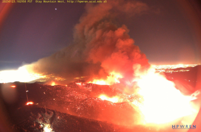
Photo, right: Border 2 Fire viewed from HP Wren Otay Mountain West camera
January 23, 2025 (San Diego’s East County) – The Border 2 Fire burning on Otay Mountain has swelled to 566 acres as of 7 p.m. tonight. The flames are visible as far north as Escondido and Ramona. There is zero containment as yet.
The fire which began early this afternoon was burning at a “dangerous” rate of spread, Watch Duty App reported, however this evening Cal Fire indicates it is growing at a moderate rate as winds have lessened.
No evacuation notices have been sent out by the County, though campers at Pio Pico and Thousand Trials have posted on social media that they were advised to evacuate or prepare to evacuate.
Update 5:05 p.m.-- The #Border2Fire is now 248 acres and still 0% contained. Winds have shifted toward campgrounds with campers at Pio Pico told to evacuate and Thousand Trails campers receiving a warning to be prepared, per social media posts from campers at these sites.
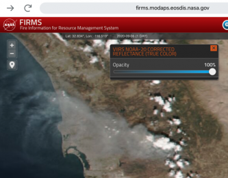 update 4 p.m.-- The fire is now 148 acres per Watch Duty app and is large enough to be visible from space. (Photo, right, via NASA)
Update 3:45 p.m.-- The fire is now 50 acres and 0% contained, per Cal Fire.
By Miriam Raftery
Photo by Barry Jantz: Border 2 Fire viewed from Jamul, with Jamul Casino in foreground.
January 23, 2025 (San Diego's East County) -- The #Border2Fire that started within the hour on Otay Mountain is now 20 acres and burning at a "dangerous" rate of spread, per Watch Duty App. Cal Fire lists the size as 10 acres with potential for 200 acres.
The fire started near Otay Truck Trail in the Otay WIlderness area. Infrastructure on the mountain is threatened, per Watch Duty App.
East County News Service
January 22, 2025 (Lemon Grove) — In the wake of the devastating fires that have swept through Los Angeles, Lemon Grove non-profit service clubs such as the Lemon Grove Lions, Lemon Grove Forward Club, Thrive, Soroptimists International of Lemon Grove, Mt. Miguel High School Alumni and the Lemon Grove Fire Department to name a few, are uniting to provide much-needed assistance to affected families and communities. These dedicated organizations are hosting a fundraising event on Sat, Feb 1st at Treganza Park from 12:00 p.m. to 3:00 p.m.
Update 4 p.m.: Evacuations have been listed and forward spread has been stopped.
Update 11 a.m. -- The evacuation center at Castle Creek Golf Course has closed. Evacutees should go to Riverview Church,4980 Sweetgrass Lane in Bonsall.
January 21, 2025 (Bonsall) -- The #LilacFire in Bonsall has burned 80 acres and destroyed two homes, with 10% containment. Mandatory evacuations have been ordered. The fire is burning along Old Highway 395 and North Lilac Rd.
View evacuation areas at the Genaysis mapping site. An evacuation center is at the Castle Creek Golf Course, 8797 Circle R Drive in Escondido 92026. Large animals can be taken to the CRC Ranch at 43101 Anza Rd in Temecula - per San Diego Sheriff's on X.
All schools in Bonsall are closed today due to the fire, according to the Bonsall Unified School District.
A second blaze that started overnight, the Pala Fire, is 100% contained at 17 acres. That fire was located west of I-15 and 2 miles north of Highway 76 in Pala.