TWO VIOLENT SEX OFFENDERS RELEASED IN CAMPO AND BORREGO SPRINGS

By Miriam Raftery

Photo:  Merle Wakefield and Alvin Quarles have been conditionally released into  Campo and Borrego Springs.

February 16, 2025 (San Diego’s East County) – The Sheriff’s department has sent warning notices to residents in Borrego Springs and Campo, announcing that two sexually violent predators have been conditionally released into these communities.  The court has ordered Liberty Healthcare, which runs the state’s conditional release program, to continue seeking permanent placement for the two men.

COMMUNITY INPUT SOUGHT ON PROPOSED PARK IN JAMUL

East County News Service

February 9, 2025 (Jamul) -- The Jamul-Dulzura Planning Group is seeking funds from San Diego County’s Department of Public Works to develop a community park in Jamul. While exploring potential locations for the park, the Planning Group has launched a survey asking community members what features they would like to see in the new community park.

“As we explore potential locations for this park, we want to ensure it meets the needs and desires of our community,” an email from the planning group states. To take the survey, click here.

JAMUL-DULZURA COMMUNITY PLANNING GROUP SEEKS CREATIVE MINDS TO DESIGN NEW LOGO

East County News Service
 
Photo:  one of the ideas for the new logo
 
February 9, 2025 (Jamul) - The Jamul-Dulzura Community Planning Group (JDCPG) is seeking creative minds to design its new logo, offering local artists and designers a chance to leave their mark on this vital East County organization.

PHOTOS OF THE WEEK: BORDER 2 FIRE

East County News Service

January 28, 2025 (Jamul) -- Robert Hobbs sent in these images of the Border 2 Fire, which burned over 6,500 acres after starting on Otay Mountain in San Diego County on Jan. 23.  These photos were taken Jan. 23 and 24 from Jamul.


TROOPS ARRIVE AT BORDER AFTER TRUMP DECLARES BORDER EMERGENCY, AUTHORIZES MIGRANT SEIZURES IN SCHOOLS, CHURCHES AND HOSPITALS

By Miriam Raftery

Photo: screenshot of aerial video by ECM news partner 10 News shows military troops with razor wire at a staging site in the South Bay, as troops prepare to deploy to fortify U.S. - Mexico Border and aid in Trump crackdown on border crossings.

January 26, 2025 (San Diego) – A tough crackdown on immigrants has begun, after President Donald Trump declared a national emergency at the Southern Border. On Thursday, 1,500 active-duty military troops have been deployed to patrol the borders in San Diego and San Antonio, Texas, with the first soldiers arriving Thursday. 10 News shot footage showing troops, including hundreds from Camp Pendleton, arriving at staging area in Imperial Beach along with concertina razor wire, tents, and military trucks.

Yet according to Associated Press, data doesn’t back up Trump’s contention of an “invasion” of immigrants.  In fact,  AP reports, “arrests for illegal border crossings plummeted more than 80% to about 47,000 in December from an all-time high of 250,000 the same period a year earlier. Arrests fell by about half when Mexican authorities increased enforcement within their own borders a year ago and by about half again when former President Joe Biden introduced severe asylum restrictions in June.”

Immigration sweeps have also begun across the nation, striking fear into immigrant communities as Border Patrol agents in some areas reportedly demanded documentation of everyone stopped, including citizens. Tom Homan, Trump’s border czar, told Fox News that ICE arrested over 308 “serious criminals” in the first 24 hours after Trump took office.

One day later, Newsweek reports, Trump’s Acting Secretary of Homeland Security  Benjamine Huffman lifted a long-standing ban, now allowing ICE to target immigrants in sensitive locations including schools, churches and hospitals.

In addition to fortifying the border to block crossings by migrants, including many seeking asylum and fleeing violence or persecution, Trump's administration has disabled the app which formerly allowed asylum-seekers to apply online without crossing the border, effectively blocking all asylum efforts, NPR reports. 

CAL FIRE HOLDS BORDER 2 FIRE TO 6,625 ACRES AS RAIN AIDS EFFORTS, BUT MUDSLIDES ARE POSSIBLE RISK

By Miriam Raftery

Photo courtesy of Cal Fire

Update January 30,2025 10 a.m.-- All evacuation orders have been lifted The fire is 100% contained.

Update January 29, 2025 9 a.m.-- The Border 2 Fire is now  90% contained, as rain helped firefighters' efforts. Cal Fire says there is no risk to the public or structure threats.

Update January 27, 2025  12 p.m.--   The overnight shelter at Cuyamaca College has closed.  All evacuation warnings remai lifted.  Some evacuation orders remain in effect in areas west of highway 94.  For map, see: https://x.com/SDSheriff/status/1883974136143438278/photo/1.  

Update 7:45 p.m. -- The fire is now 40% contained, per Cal Fire.

Update 5 p.m.-- All evacuation warnings have been lifted.  Some evacuation orders remain in areas west of 94. Use caution when reentering, as firefighters are still at work.  

Update 1 p.m.-- State Route 94 is reopened; evacuation notices for Dulzura, Honey Springs, and areas east of 94 have been lifted; these areas will be repopulated. Otay Lakes Rd. remains closed.  To see maps of the affected areas, visit: emergencymap.sandiegocounty.gov/index.html and protect.genasys.com/fullscreenMap?.

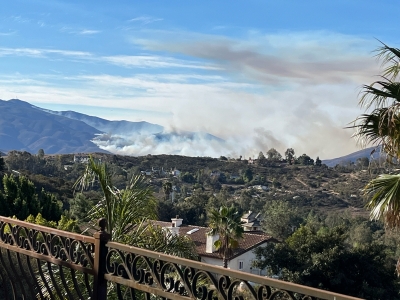
January 26, 2025  8:30 a.m.— Firefighters held the #Border2Fire to 6,625 acres overnight and 10% contained. State Route 94 remains closed between Honey Springs Road and State Route 188.Tecate Rd.  Evacuations remain in effect; view current evacuation areas: Genasys Evacuation Map.  1,117 personnel are fighting this fire.

Experts are looking at the soil in the fire’s perimeter to evaluate if there are any mudslide concerns and will work to mitigate those if they arise.

Cal Fire held a virtual community forum last night which can be viewed here. Cal Fire reports good progress on the fire, especially on the west side near Chula Vista  Due to improved conditions, the Sheriff reports that jail visits will resume at the 3 Otay facilities.

On the east side and near Doghouse Junction, crews are constructing a containment line to prevent the fire from moving east towards Dulzura, Marron Valley, and Mexico.

.On the south side of the fire, there is some open line on the fire, but resources are working in arduous terrain to combat it. On the southwest side, ground crews and dozers continue to build line to prevent the fire’s spread.

EVACUATION AREAS EXPAND IN BORDER FIRE; EVACUATION CENTER AT CUYAMACA COLLEGE

Update January 25, 2025- The fire had modest growth overnight and is now 6,500 acres, per Cal Fire.

Update 8:15 p.m.-- Per CalTrans, State Route 94 is closed in both directions between Honey Springs Rd. in Jamul and State Route 188 (access road to Tecate) due to the fire.

Update 5:55 p.m.-- The fire is now 6,272.7 acres per Cal-Fire. The mandatory evacuation area has been extended to some areas east of State Route 94.

January 24, 2025 (Jamul/Dulzura) -- Evacuation orders and warnings for the #Border2Fire now extend to immediately south of Jamul Casino, including areas east and west of State Route 94, and significant portions of Chula Vista.  Photo left is as of 1 p.m.; click this link for latest evacuation areas and hit the plus sign to enlarge to view details: https://app.watchduty.org/camera/2231   Also see another map here:  https://www.fire.ca.gov/incidents/2025/1/23/border-2-fire.

The fire, which started on Otay Mountain yesterday,  is now 5,389 acres and 10% contained per Cal Fire.  An Evacuation Center has now been set up at: Cuyamaca College 900 Rancho San Diego Parkway, El Cajon, CA 92019. 

SCHOOLS CLOSE DUE TO FIRES AND POWER OUTAGES

East County News Service

January 24, 2025 (San Diego's East County) -- The  San Diego County Office of Education has announced numerous school closures today due to the Border 2 Fire as well as power outages.

Power outages have resulted in closure of all Mountain Empire Unified School District and Warner Unified School district campuses today, as well as all Borrego Unified School District and Dehesa School District schools.. Currently over 19,000 customers are without power due to public power safety shutoffs, with more than 63,000 more at risk of losing power. For updates on power outages due to public safety shutoffs, visit https://www.sdge.com/psps-dashboard.

The Border 2 Fire has caused closures of the following schools:   Eastlake High, Eastlake Middle, East Hills Academy in the Sweetwater Union High School District,High Tech High in CHuula Vista, Arroya Vista Charter School, and in the Chula Vista Elementary School District Arroyo Vista, Camarena, Eastlake, Liberty, Marshall, Olympic View, Salt Creek, and Wolf Canyon elementary schools are closed; all other CVESD schools remain open but on rainy day schedule due to poor air quality.

EVACUATIONS ORDERED AS BORDER 2 FIRE BURNS THOUSANDS OF ACRES

Update 12 p.m.:  Cal Fire has mapped the fire at 5,389 acres. It remains 10% contained. View laetst evacuation areas, whcih have expanded,  here:  https://app.watchduty.org/i/41110 

By Miriam Raftery

January 24, 2025 (San Diego’s East County) – The #Border2Fire has exploded overnight to 4,250 acres with 10% containment, Cal Fire reports this morning.  Per San Diego County Sheriff, #Border2Fire. An evacuation order has been issued for people who live in the red shaded areas as shown on the map at left as of early this morning. It means there is an immediate threat and you need to leave right now. An evacuation warning has also been issued for the areas in yellow.

Areas under evacuation notices include Dulzura, portions of Jamul, Lower Otay Reservoir, Otay Mt. Truck Trail, Campo Rd., the Elite Training Center and more. Otay Ranch Town Center and Olympian High School are under evacuation advisories.

Evacuation Points: Red Cross volunteers are supporting two temporary evacuation points: 

  • Edwards Theater, 2951 Jamacha Rd., El Cajon
  • Southwestern College, 900 Otay Lakes Rd, Chula Vista


Note: Evacuations orders and warnings may be updated frequently; for the most recent maps please see:

https://protect.genasys.com/fullscreenMap?  and

http://emergencymap.sandiegocounty.gov/index.html